Skip to content

By audrey

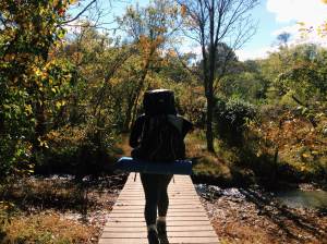
I think one of the best parts of exchange in DC is the access to national parks that are within driving distance whether in Virginia, West Virginia or Maryland. Being located in such a prime location on the east coast meant that hiking the Appalachian Trail is possible for a day trip and without the added cost of camping and plane tickets.

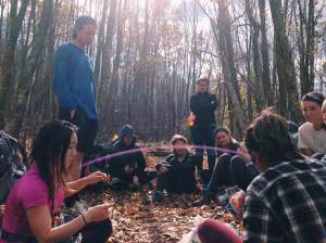
So on Saturday, the 5 of us rented a car and took a day trip to Harper's Ferry and Shenandoah National Park. Aiming to cover 2 destinations in a day was really ambitious, and to top it off, it rained while we were at out first destination so we could not do much. That being said, we decided to head off to Shenandoah National Park ahead of schedule and it was probably the best decision made that day.

Harper's Ferry is situated at the confluence of the Potomac and Shenandoah rivers where  Maryland, Virginia and West Virginia meet. It is the easternmost town in West Virginia. Driving in, you will be greeted with the sight of a quaint historical town that very much resembles colonial days and this is probably because it was an important site of the American Civil War. We took a break there from an hour's drive and treated ourselves to some food and ice cream.

While I recommend hiking up the Maryland Heights trail, we were simply not blessed with good weather.

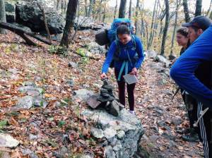
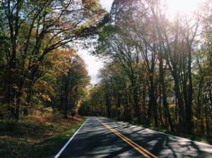
Next stop, we drove for another hour to Shenandoah National Park via the Thornton Gap Entrance (There are four entrances but this is the nearest from DC and also intercepts the Skyline Drive halfway). With national parks, cellphone reception is always a problem so I do recommend downloading the park's map before you enter for ease of navigation (unless you're an expert at reading analog maps, which we found out that we were inept at a little too late).

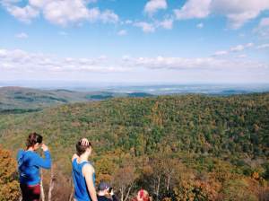
Shenandoah Park is filled with many wonderful viewpoints and waterfalls but due to time constraints, we chose to do the Hawksbill Trail, which led us to the highest point in the park. Man, the view was all sorts of spectacular despite the cold and unrelenting weather - I managed to get some pictures but the cloudy backdrop didn't do it justice.

Kudos to the drivers who survived the nearly 6-hour drive, it was really not easy for them while us non-drivers simply snacked and napped at the back!

By audrey

Fresh off our Yosemite hike, we immediately drove back to LA where we took a well-needed rest for our next adventure - traversing through the canyons. We planned on visiting Bryce Canyon, Antelope Canyon and the Grand Canyon over the next 3 to 4 days and combined, it was one heck of a drive.

Situated in Utah, Bryce Canyon is known for its crimson-colored hoodoos, or spire-shaped rock formations. We drove to sunset point, which as the name suggests, is famed for its aerial views during sunset of the canyon. As we had time to spare, we actually chanced upon another lookout point called Cedar Breaks National Monument and I reckoned this was my favorite spot in Utah not simply because of its picturesque views, but also because of its coincidental nature on our trip. Of a high altitude and bordering a ski resort, we were not dressed for this - half of us were wearing shorts because of the 90 degree AZ weather while we were driving in. Nonetheless, as we clawed knee deep into powdery snow and as the winds blew our ears numb, the view and the ensuing pictures were worth the effort.

Next up was Antelope Canyon. Do note that you'll need to engage a tour when visiting Antelope Canyon as private campers or visitors will be barred. This formation was surreal - it actually looked like something out of Lord of The Rings or Game of Thrones; I half imagined Orcs to be marching behind us as we descended into the Lower Antelope Canyon. The tour guides were really helpful, constantly pointing out the different shapes and creatures morphed by the rock formations (although I didn't understood like half of them, it was still fun to hear).


The final one is perhaps the most famous of all - Grand Canyon. The rock formation in Grand Canyon is unique due to the many layers of red rock, revealing the conditions it has weathered through millions of years. While we did not have much time at our last stop, the scenery was indeed breathtaking; I also managed to mail out several postcards from the gift shop right outside one of the lookout points.

Oh and since Horseshoe Bend was a 20 min drive away - it didn't hurt! I mean, what is 20 min more of driving when we've been driving for weeks, am I right?


Many of my friends back in Singapore chose Europe as an exchange destination because they felt it had more to offer in terms of nature. After traversing 4 national parks in a week, I don't think I've been more humbled by what Mother Nature has to offer - I've definitely made the right decision in coming to the United States and using Spring Break to get away from city life and into the arms (literally, in Bryce Canyon) of Gaia.

I'm thinking of doing part of the Appalachian trial in West Virginia before the semester ends. Anybody interested? (Hint: I need a driver though)

Back to the daily grind for now.

By itsmaggiegwu

From Rural King (Front Royal) to Thorton Gap. 4 days, 3 nights, 31 miles (~50km) and 0 showers later, we finally made it through (a portion of) Shenandoah!

Fall break was the perfect time to take a break from the hustle and bustle of D.C. and immerse in the great outdoors. With 6 GW Trails Guides and 11 students, we were ready to commence a 4-day hike that would push us mentally and physically to the extreme.

maggie-zhang-10-25

We arrived at Front Royal. About an hour drive from D.C. sits a town that was just outside of the start of the Shenandoah Trail. The guides shuttled hikers in Enterprise vans. The wind was cold, but the sun compensated by its warmth. There was a couple with their Blue Heeler that had just finished the hike and told us it was going to be a cold day. We stopped for lunch on the side of the trail. We had food spread amongst the packs we had on our back. Tortilla, summer sausage and cheese with a hint of Sriracha sauce never tasted so good. It was the first time I'd ever backpacked. I've done hiking and camping, but never the both combined. It's a different experience. First off, you have to carry a heavy pack that will have the minimum amount of equipment to keep you warm. A sleeping back, sleeping pad, change of clothes and toiletries were pushed and shoved inside the 55L pack borrowed from Trails Gear (a place that rents out gear for free if you're going on a Trails trip). With only 6 miles to be completed today, we arrived promptly at the first shelter. The shelter was a three sided wooden structure with a deck out front. There was a privy nearby, which made me appreciate the modern toilet a whole lot more. Dinner was quesadilla which served as a hand warmer and food. The wind was howling by this point and everyone was miserable. Starting a fire in this kind of wind was difficult but once it was started, the warmth lured us like moth to the light. Camp fire stories were told and eventually it was time for bed. Sleeping in a tent with 5 people that was meant for 3 was cozy but the roaring wind was the thing that kept everyone awake.

maggie-zhang-10-25-2 maggie-zhang-10-25-3

The next two days were faced with difficult hikes but albeit better weather conditions (sunny with very little wind). 10 miles on Sunday and another 13 miles on Monday. By that time we were somewhat comfortable with the routine. We woke up at 7:30am and aimed for a 9am start. Lunch was served at around 12:30pm somewhere along the trail. Apples, clementines kept us hydrated and the trail mix from Trader Joe's kept us motivated. By the end it was a matter of putting one foot in front of the other that pushed us through to the end. Great friendships were made as we bonded over the fires and the making of s'mores which made it all the more sad when Tuesday came. It was back to reality, to the homework and classes. But I'm sure that there will be more hikes to come - maybe GW Trails to Mary's Rock?

maggie-zhang-10-25-4 maggie-zhang-10-25-5