Skip to content

In a world where you can make phone calls from your watch and donate rice to the hungry by knowing vocabulary words, it's easier than ever to make a difference. Sometimes it can seem like all doom and gloom - sea levels are rising, the United States faced a record number of "megadisasters" in 2017, and temperatures in Jacksonville, FL were colder than those in Anchorage, AK. The good news, is that technology gives us the chance to help the world without having to un-bundle from blankets, dig out from under snow, or even take a shower (it's not too good to be true, promise).

One of the environmental challenges facing communities across Africa is the threat of flooding. Lots of communities are built along rivers, relying on the water source for agriculture, transportation, and drinking water. This is great - until a flood occurs. Many of these communities are very isolated, and do not have strong emergency response plans in the event of a flood. Flooding devastates towns, displaces populations, destroys agriculture, and spreads dangerous diseases. Until recently, it was very difficult to create strong emergency plans - and to even know which communities were most vulnerable.

The Red Cross in Togo, West Africa

YouthMappers has teamed up with The George Washington University, the World Bank, and the Red Cross to help communities better prepare for floods! Using satellite data, volunteers across the world can go online, and help generate data for international organizations trying to help.  The World Bank and The Red Cross are already using this data to help them target their interventions.

...continue reading "Tackling Africa’s Floods – A Call for Mappers! | Bridget Smith; Michael Mann"

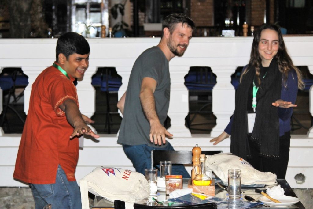
“Hello! My name is Ben and I’m from Ghana. I like to…” then Ben slid his arm forward simulating the movements in a game of chess on an imaginary board. The circle of 30 strangers from around the world had to repeat Ben’s name, mimic his action, and then move on to the next person in the large circle. This initially embarrassing, but ultimately hilarious ice-breaker was the beginning of an engaging, demanding, and rewarding YouthMappers Fellows Leadership Workshop – the first of its kind – held in Kathmandu Nepal, in May, 2017.

YouthMappers student Fellows Manjurul Islam, Frikan Erwee, and Sasha Guttentag repeat
Faculty Facilitator, Richard Hinton’s, favorite activity – which is snowboarding.

YouthMappers is a network of university-affiliated chapters from around the world (currently 67 chapters in 23 countries and growing!) which creates free and open geospatial data used to address specific development objectives in USAID affiliated countries. YouthMappers students create original, quality, localized geospatial data in unmapped places of the world to support local development goals, and to help communities prepare for disasters.

...continue reading "Mapping it all in Kathmandu, Nepal | Joe Dymond; Nuala Cowan; Richard Hinton"

The vast Arctic territory is rich in resources including minerals, hydrocarbons, and wildlife. However, high latitudinal regions receive little sunlight for several months each year, which severely limits the region’s ability to grow fresh produce. Many Arctic urban centers rely on long, complex supply chains to receive shipments of fresh fruits and vegetables from their southerly neighbors.

Alaska imports about 95% of its fresh produce, moving about $2 billion per year of grocery spending out-of-state. Produce destined for the Arctic has to be picked early and ripened in-transit to minimize rot during the long journey from farm to table. Such practices affect the quality of produce polar consumers can buy and drive up prices. Arctic residents often pay exorbitant prices for items as simple as a head of lettuce.

...continue reading "Tundra to Table: Vertical Farming in the Arctic | Luis Suter"

This piece was originally published by Latin American Policy Organization (LAPO).

Chile has become the leading Latin American producer of solar Photovoltaic (PV) energy. The production of solar energy expanded so quickly that Chile is giving away electricity for free in certain parts of the country.

A country once closely associated with dirty environmental habits such as mining and an energetic dependency on coal and gas-fired electricity plants, Chile is turning into a clean energy frontier. It has been a testing ground for governments and companies to experiment with policy, and the investment has paid off.

...continue reading "The Chilean Case for Solar Energy | Cody Etlin"

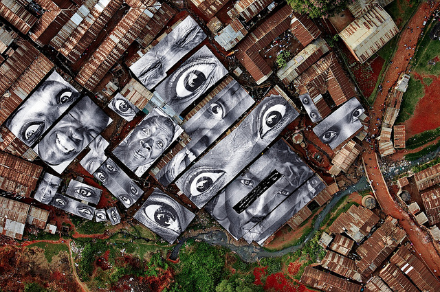
Women Are Heroes
Rooftops covered with the eyes and faces of the women of Kibera. Women Are Heroes project, 2009.

I’ve been slumming for more than 15 years, wearing my best smile and my oldest clothes, drawn to areas of deliberate neglect in African slums. In early August, I traveled to Nairobi along with my SMPA colleague, Steven Livingston. We met with a group of community leaders in Mathare, a slum on the east side of Nairobi.

Communities such as Mathare and Kibera in Nairobi are points of entry for internal migrants from the Kenyan countryside. Increasingly they are empowered by the connective technology of mobile phones and social networking sites like Facebook. As we saw in August, these slums are often frothed by rising expectations. Residents want to do more than be “on the map.” They want education and access to opportunity, skills, and jobs. They would like more attention from their elected officials. ...continue reading "Digitize Me a Job! | David Rain"

This piece was originally published by the National Mall Coalition.

What gives the Mall its meaning is the ways in which we use the Mall as a public space; shown here is a July 4th celebration. If we allow the erosion of public use to continue, will events like this become a thing of the past?

What gives the Mall its meaning is the ways in which we use the Mall as a public space; shown here is a July 4th celebration. If we allow the erosion of public use to continue, will events like this become a thing of the past?

The National Mall is our nation’s premier public space. It is the stage for American democracy, a destination for exploring the country’s history, a place for entertainment, inspiration, and recreation. We inaugurate presidents here. We commemorate important events and people. We reflect on war and loss. We celebrate the founding ideals of liberty, freedom and democracy. Each year, more than 25 million Americans and tourists from abroad visit the Mall to take in its inspiring memorials, museums, and other attractions. Local residents, too, make great use of the open space for organized sports. Ultimately, it is “we the people” and how we use the Mall that makes it such an important public space in American civic life.

Over the last few years, as I researched my new book, The National Mall: No Ordinary Public Space, I came to appreciate how crucial public use of this open space is to the health of our democracy. And yet, there are troubling signs that public use and access are eroding, slowly and quietly.

...continue reading "Turf War on the National Mall? | Lisa Benton-Short; Gordon Binder"

1

Although Geography occasionally suffered from name recognition in the past (it’s Geography not Geology!), the hard work of geographic education advocates, coupled with increasing connectivity around the world, changing spatial awareness (through the everyday use of platforms like Google Maps and global phenomena such as climate change) and rapidly developing geospatial techniques, suggest the potential development of a new, and perhaps enlightened era for Geography.

This blog post is the first in a new GWU Department of Geography blog series. The Geography Department invites Geography faculty, current students, and alumni to get involved in the dynamic and diverse conversation this blog series creates. For our debut post, I am here to examine trends and significant developments in U.S. geographic education and in geography’s relevance. Geographic education has become the object of newfound awareness and acceptance in recent years in the United States. Its (re)incorporation can be seen across all education levels, from primary to post-secondary.

...continue reading "What’s Trending in Geography and Geographic Education? Rapid Growth – That’s What! | Joe Dymond"